District-Scale Gold Exploration in Alaska’s Richardson Mining District
Key Highlights
52,920 Acres | 368 Claims
A dominant land position in the Richardson Mining District of east-central Alaska.
120,000+ oz Historic District Gold
The Richardson District has produced more than 120,000 ounces of alluvial gold since placer discovery on Tenderfoot Creek in 1905.
Highway, Pipeline, and Power
The property sits along the Alaska Highway, adjacent to the Trans Alaska Pipeline, with a high-voltage power line traversing through its southern boundary.
Three Deposit Models
Prospective for Pogo-type quartz vein gold, Fort Knox-type intrusion-related gold, and rhyolite dike-hosted mineralization.
Overview
Project Overview
Shamrock is a district-scale gold exploration project in the Richardson Mining District of east-central Alaska, approximately 113 kilometers (70 miles) from Fairbanks along the Alaska Highway corridor. Contango staked the property in 2021, assembling 368 State of Alaska mining claims covering approximately 52,920 acres and a dominant position in the district.
Infrastructure is a defining advantage. The property fronts the Alaska Highway, is adjacent to the Trans Alaska Pipeline, and is crossed along its southern boundary by the high-voltage power line that feeds the Pogo gold mine, located about 80 kilometers to the northeast. Gravel roads and ATV trails provide good access across the property.
The property is underlain by metamorphic schists and gneisses of the Lake George Subterrane of the Yukon Tanana Terrane, the same regional host to a number of large gold deposits across interior Alaska and the Yukon. Two ages of mid-Cretaceous intrusive activity on the property are genetically related to lode gold mineralization in the region.
Key Project Metrics
LocationRichardson Mining District, east-central Alaska; approximately 70 miles southeast of Fairbanks along the Alaska Highway
Ownership100% Contango Silver & Gold; 368 State of Alaska mining claims; over $9 million in exploration expenditures to date
AccessAlaska Highway frontage with gravel roads and ATV trails across the property
Strategy
Exploration Rationale & Plan
Contango is exploring for three gold deposit types at Shamrock: gold in low-angle quartz veins of the Pogo type, intrusion-related gold deposits of the Fort Knox type where intrusions intersect deep-seated crustal structures, and high-level rhyolite dikes with associated clay and silica alteration in the Democrat and Banner Dikes area. There are multiple drill-ready intrusion-related gold targets.
The property was previously held by Coeur Mining, which inherited it through a corporate acquisition, deemed it non-core, and dropped the claims in 2020. Historic work left behind a number of well-defined soil anomalies with only limited drilling. Contango has compiled all previously acquired geochemical sampling, drilling, and geophysical data and is advancing the under-explored anomalies toward drill targets.
Image Gallery
Shamrock- 1 Property plan view
Shamrock – 2 Figure 1. Location map for the Shamrock Project, Alaska
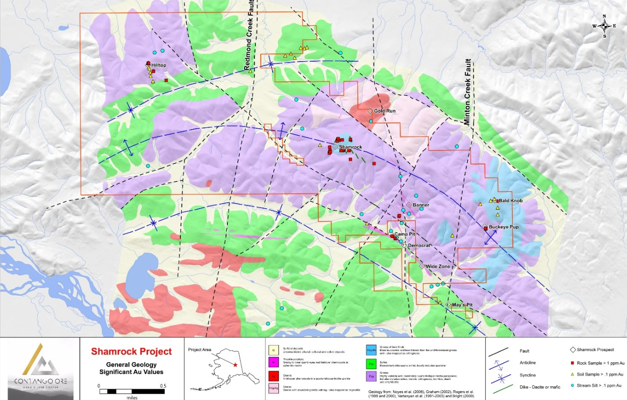
Shamrock – 3 Figure 2. Map showing the general geology of the Shamrock property, Richardson district, east-central Alaska
Shamrock – 4 Figure 3. Map showing the Tintina Gold Belt, Alaska and the Yukon
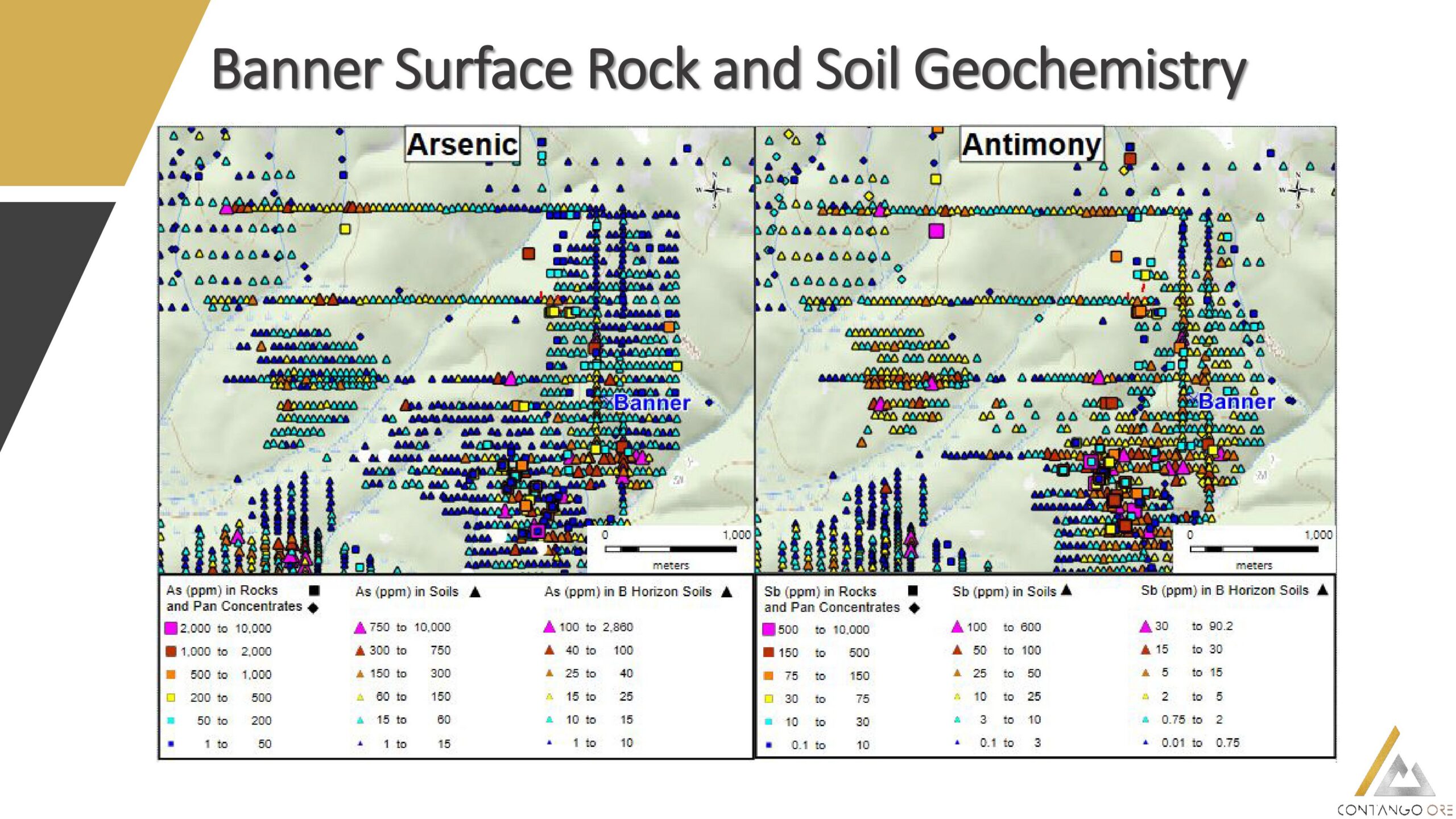
Shamrock – Banner Surface Rock and Soil Geochemistry_As-Sb
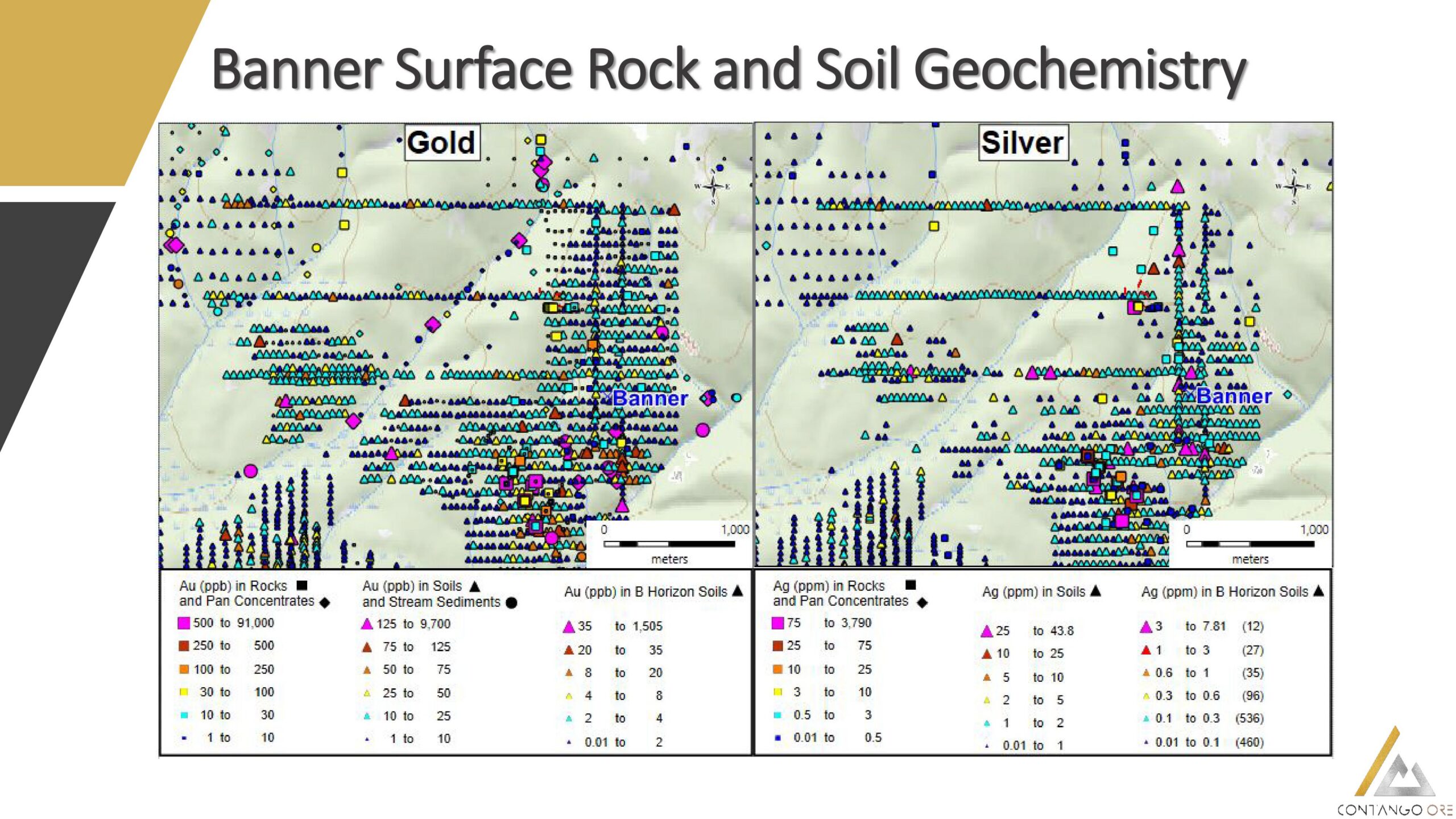
Shamrock – Banner Surface Rock and Soil Geochemistry_Au-Ag
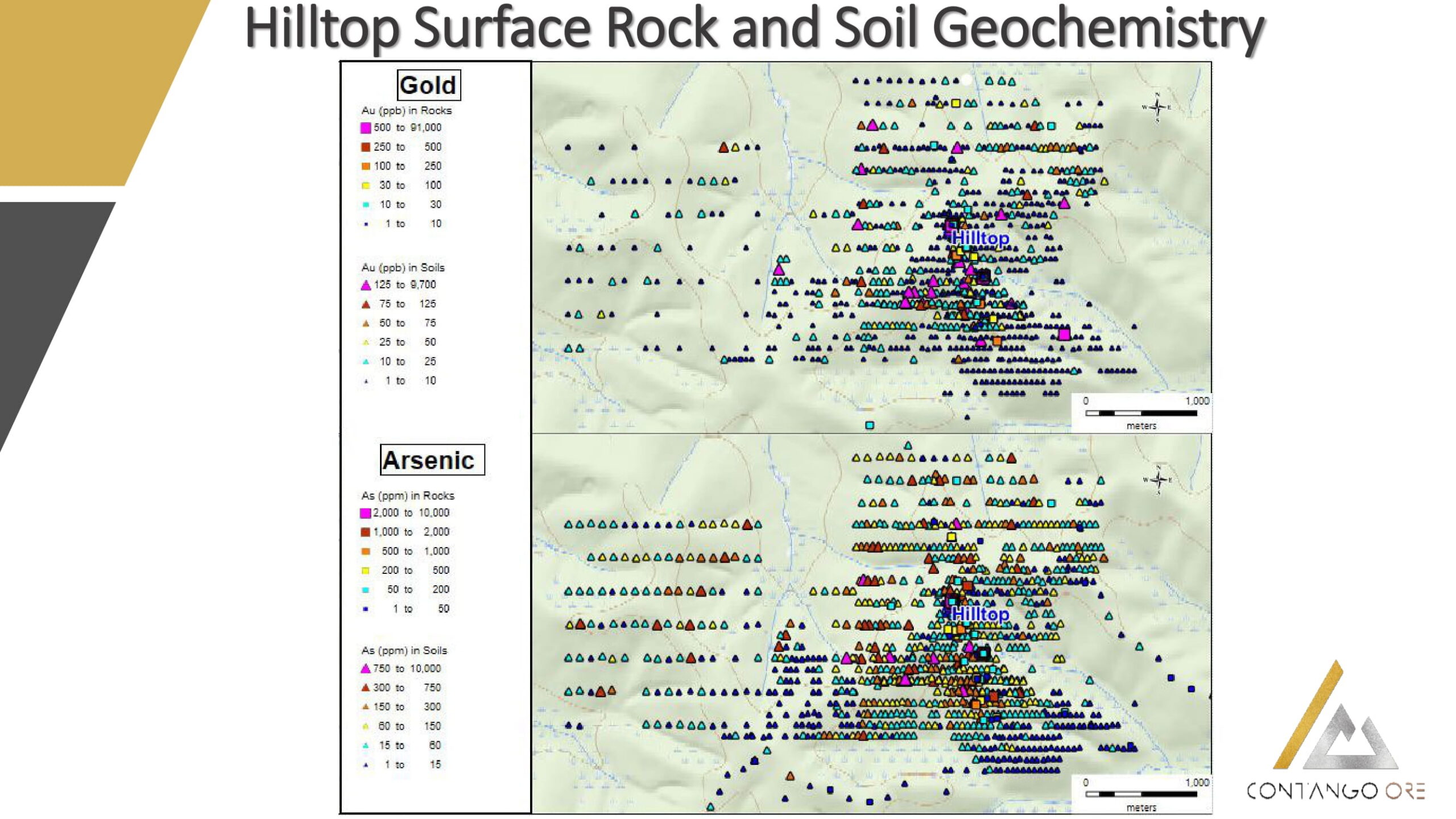
Shamrock – Hilltop Surface Rock and Soil Geochemistry_Au-As-1
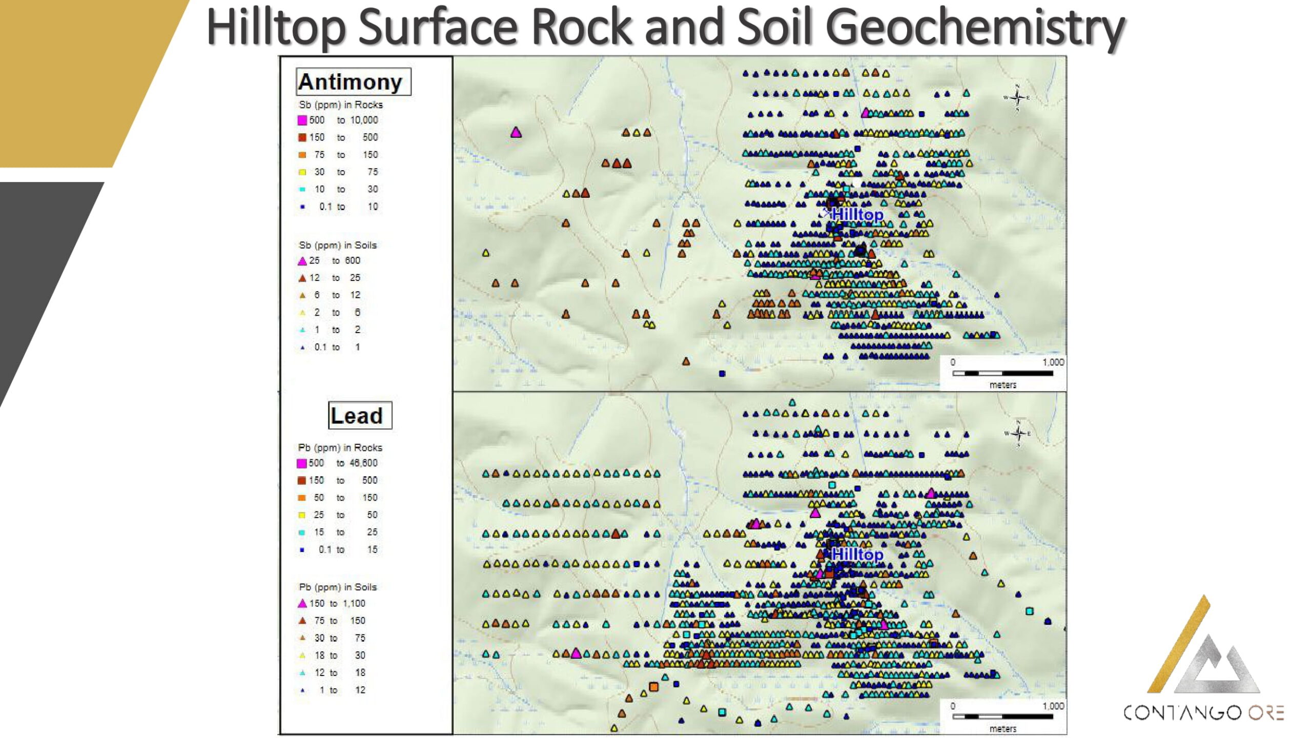
Shamrock – Hilltop Surface Rock and Soil Geochemistry_Sb-Pb-1