CTGO:CA:

CTGO:

SILVER:

GOLD:

Kitsault Valley Project

Kitsault Valley Project


District-Scale High-Grade Silver and Gold Cornerstone Position in British Columbia’s Golden Triangle

Key Highlights

163 km² | 100% Held

Contango holds 100% of the consolidated 16,300-hectare Kitsault Valley district, one of the largest land positions in the southern Golden Triangle.

58.70 Moz Indicated Ag | 22.8 Moz Inferred Ag

Combined project resources also include 394,000 ounces of gold Indicated and 677,000 ounces of gold Inferred, split roughly 50/50 between silver and gold by value.

Eight Precious Metal Deposits

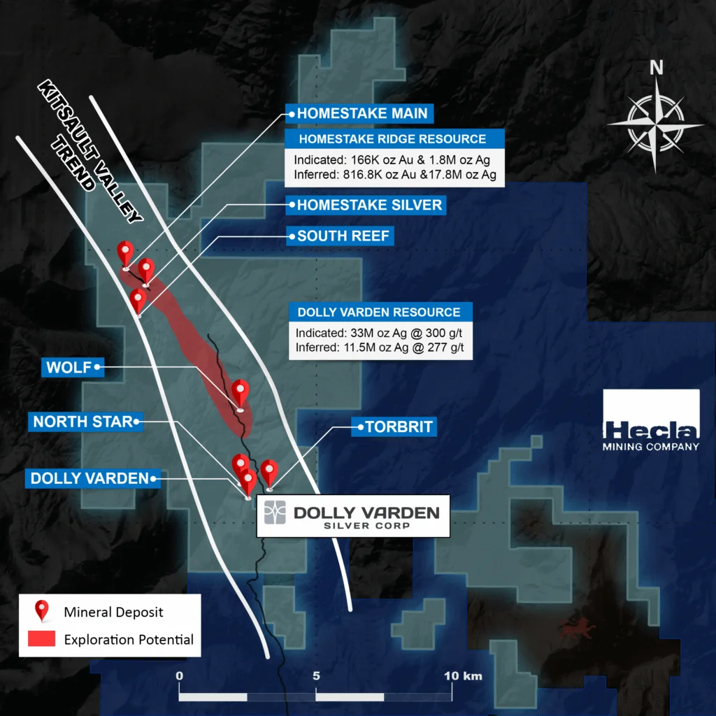
The Kitsault Valley Trend hosts seven known deposits across the silver-rich Dolly Varden area and the gold-rich Homestake Ridge areas.

Golden Triangle Address

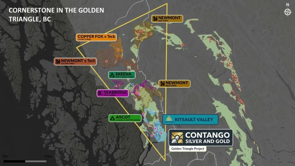
Located just south of the high-grade Brucejack and Eskay Creek mines, with a 25-kilometer access road to deep water and grid power at the town of Kitsault.

Overview

Project Overview

The Kitsault Valley project is Contango Silver & Gold’s British Columbia silver hub. The 100% held, 163-square-kilometer project sits at the southern tip of the Golden Triangle, just south of the high-grade Brucejack and Eskay Creek gold mines, and hosts a high-grade mineral resource of silver and gold with strong potential for further precious metal discoveries.

The consolidated project combines two distinct metallogenic hubs along the highly mineralized Kitsault Valley Trend: the Dolly Varden properties with its silver-rich resources, the Homestake Ridge property with gold, silver, copper, and lead resources. Together they host eight known precious metal deposits, giving the project a resource base measured roughly 50/50 between silver and gold by value.

The district was consolidated in February 2022, when Dolly Varden Silver Corp. acquired the adjacent Homestake Ridge project from Fury Gold Mines, and joined the Contango portfolio through the merger of Contango ORE and Dolly Varden Silver completed in March 2026. Contango now advances the district within the regionally important Stewart Complex of northwestern British Columbia, north of Alice Arm.

Key Project Metrics

Current M&I Resource ~700 koz GEO; Inferred Resource: 1.3Moz GEO
Location Southern Cornerstone of the Golden Triangle, northwestern British Columbia, Canada; north of Alice Arm, within the Stewart Complex
Ownership 100% Contango Silver & Gold
Status Advanced Exploration
Deposit Type Precious metal rich epithermal veins (Dolly Varden, Homestake Ridge); porphyry copper-gold (Big Bulk)
Property Size 16,300 hectares (163 km²; approximately 40,280 acres)
Host Rock / Age Jurassic volcanic and sedimentary rocks of the Hazelton Group (Betty Creek and Salmon River formations)
Main Economic Elements Silver and gold, with copper and lead credits
Current M&I Resource 166k oz Gold and 34.7 M oz Silver; Inferred Resource: 817k oz Gold and 29.3 M oz Silver
Mine Method Underground (potential); historic underground production at Dolly Varden and Torbrit
Access / Infrastructure 25-kilometer access road to deep water and electricity at the nearby town of Kitsault; adjacent to Hecla Mining's Kinskuch property
Project Story

Watch the Kitsault Valley project video and the latest drilling coverage in the Media section.

Geology & Mineralization

Combined resources of the Kitsault Valley project:

Table 1. Mineral resource summary by area and classification (effective September 11, 2026).

AreaCategoryTonnage
(Mt)
Ag
(Moz)
Au
(koz)
Cu
(Mlb)
Pb
(Mlb)
Zn
(Mlb)
AgEq
(Moz)
HomestakeIndicated2.146.13387.426.325.967.0233.28
Dolly VardenIndicated5.5252.577.293.0672.2081.8356.27
Project TotalIndicated7.6658.70394.709.3878.1688.8589.55
HomestakeInferred4.607.97615.824.2416.8614.69¹48.50
Dolly VardenInferred1.7114.844.991.8023.3833.9216.42
Project TotalInferred6.3122.80620.826.0440.2448.61¹64.92

Table 2. Mineral resource summary by grade (effective September 11, 2026).

CategoryAreaTonnes
(Mt)
Ag
(g/t)
Au
(g/t)
Cu
(%)
Zn
(%)
Pb
(%)
AgEq
(g/t)
AgEq
(Moz)
IndicatedHomestake2.1489.145.630.130.150.13483.733.28
Dolly Varden5.52296.10.040.030.670.59317.0656.27
Total7.66238.341.600.060.530.46363.089.55
InferredHomestake4.6053.914.170.040.150.17328.3048.50
Dolly Varden1.71269.910.100.050.900.62289.6516.42
Total6.31112.503.060.040.350.29320.2664.92

Dolly Varden Property

The Dolly Varden property comprises the 88-square-kilometer southern half of the project and features a high-grade, 100% silver resource across four known deposits: Wolf, North Star, Dolly Varden, and Torbrit. The property encompasses several historic underground workings, including production stopes from the Dolly Varden and Torbrit mines and exploration adits at North Star and Wolf.

Metallurgical test work indicates strong silver recoveries, with combined flotation and cyanidation recoveries of 84% at Dolly Varden and 88% at Torbrit, and whole ore cyanidation recoveries of 86% to 87%.

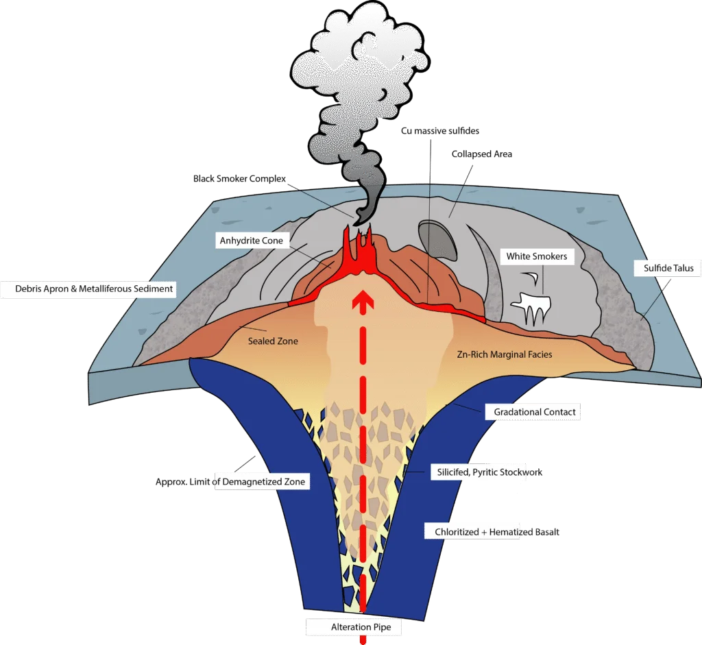
Property geology. The property is underlain by volcano-sedimentary rocks of the lower and middle Jurassic Hazelton Group, including the Betty Creek and Salmon River formations. The principal silver-base metal deposits are interpreted as volcanic exhalative in origin, formed as sub-aqueous hot spring deposits on the seafloor. The most prominent mineralized zone is the Dolly Varden-Torbrit Horizon (DVTH), an aerially extensive exhalative sheet ranging from 3 to 38 meters in true thickness that extends from the Dolly Varden mine through North Star to the Torbrit mine. The Red Point and Wolf zones sit higher in the volcanic stratigraphy and share the targeted hydrothermal vein and hot spring geology.

Eskay Creek analog. The Torbrit deposit, which hosts the bulk of the property’s resources, is a low-sulphidation example of the same class of precious metal rich VMS deposits exemplified by Eskay Creek, where stratiform layers of precious metal rich chemical sediments and massive sulphides accumulate near seafloor vents underlain by feeder veins, stockworks, and strong alteration. The DVT Exhalite correlates with the barite-silica cap in this model, and the Redpoint Feeder Zone with the footwall stockwork alteration, providing a direct exploration analog on the property.

Homestake Ridge Property

Homestake Ridge comprises the 75-square-kilometer northern half of the project and features a high-grade gold and silver resource across three known deposits: Homestake Main, Homestake Silver, and South Reef. Mineralization is interpreted as structurally controlled epithermal veins and breccia systems within the same prospective Jurassic Hazelton Group that hosts the Dolly Varden deposits. More than 90,000 meters in 275 holes have been drilled at Homestake Ridge.

Project History

Silver was first produced in the district a century ago: the Dolly Varden mine produced 1.3 million ounces at 1,109 g/t Ag from 1919 to 1921 from epithermal silver veins, and the Torbrit mine produced 18.7 million ounces at 466 g/t Ag with base metal credits from 1949 to 1959. Dolly Varden Silver Corp. consolidated the district in February 2022 by acquiring the adjacent Homestake Ridge project from Fury Gold Mines, creating the combined Kitsault Valley project. The project became part of Contango Silver & Gold through the merger of Contango ORE and Dolly Varden Silver completed in March 2026.

Historic production figures are based on reports filed by prior owners and operators. The Company has not undertaken independent work to verify the previously reported information.

Current Program / Path Forward

Contango is drilling at Kitsault Valley with the objective of growing the high-grade silver and gold resource base along the Kitsault Valley Trend and testing the exploration upside of the consolidated district. The project’s scale, established access to tidewater and power, and position in the prolific Stewart Complex make it the centerpiece of the Company’s non-dilutive growth strategy in British Columbia.

Quick Links

Image Gallery

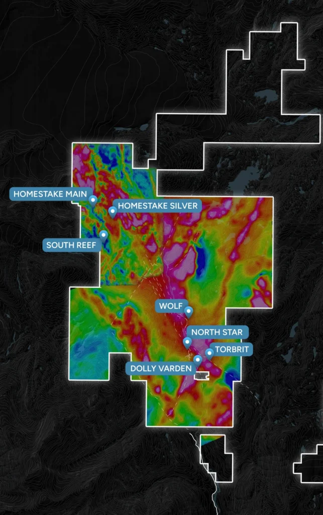
Magnetics map of the Kitsault Valley property with deposit locations
Magnetics Scaled Map
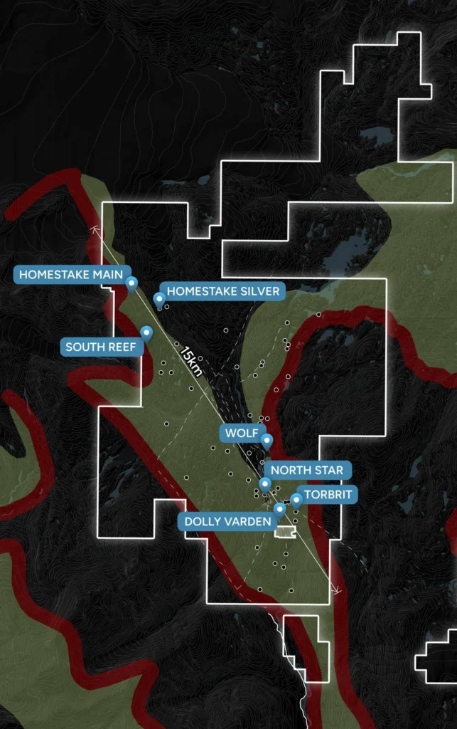
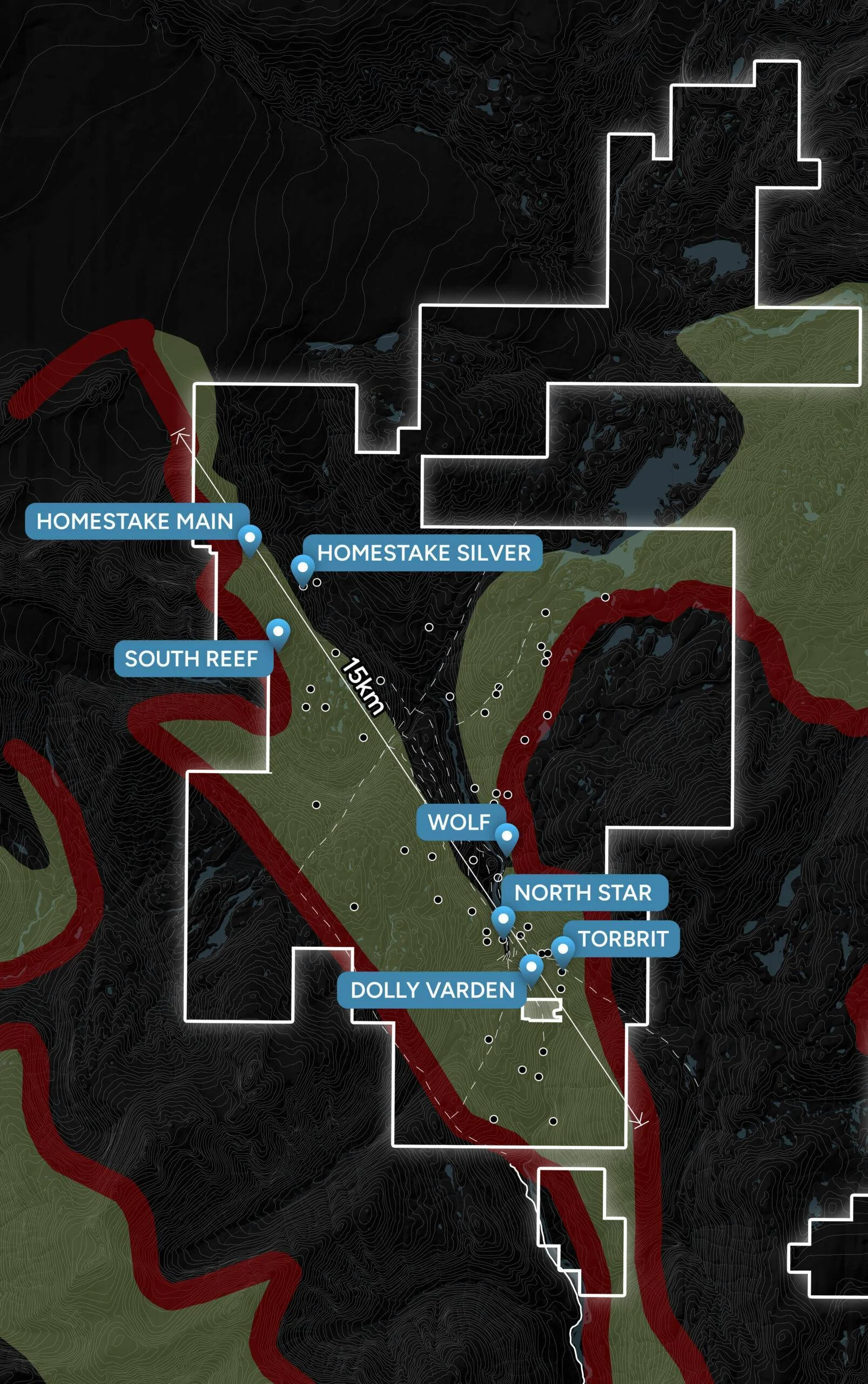
Kitsault Valley property map showing the mineralized trend and deposits
Mineralized Trend Map
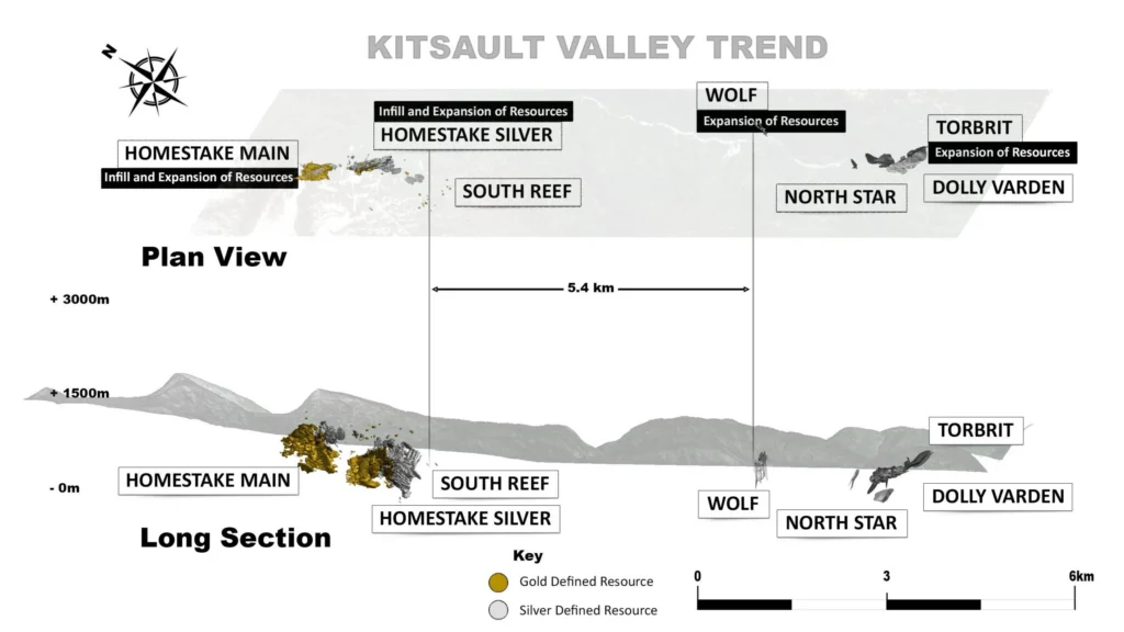
Kitsault Valley Trend plan view and long section from Homestake Main to Dolly Varden
Kitsault Valley Trend
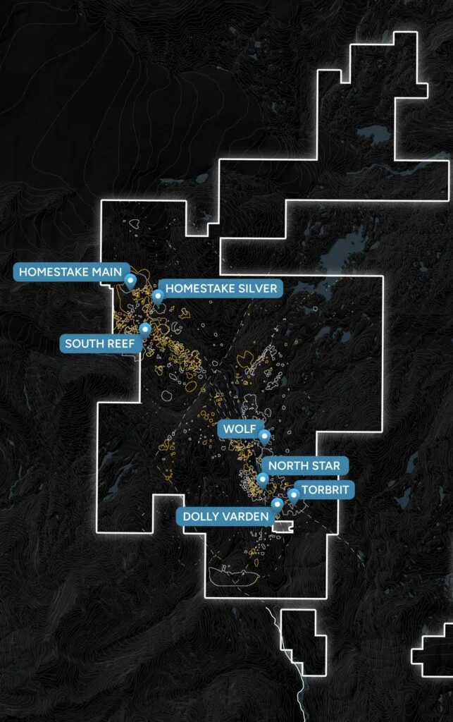
Geochemistry map of the Kitsault Valley property with deposit locations
Geochem Scaled
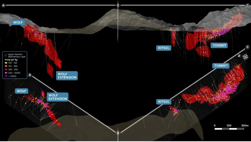
Section of gold and silver mineralization at the Wolf and Torbrit deposits
Contango GoldSilver Map
Kitsault Valley property map with the mineralized trend outlined
Mineralized Trend
Golden Triangle Map
Golden Triangle Map
Map of the Dolly Varden and Homestake resources along the Kitsault Valley trend
Dolly Varden Kitsault Valley
Cross-section diagram of mineral deposit types formed around a volcano
Volcano Map